Karst Trail, Rock Bridge State Park

Finally, I am back to writing about what I love to write about most - the outdoors! It seems like so long since we have been out hiking. We went out once in June to a new trail in Mark Twain forest, but were incredibly disappointed when we found the trail to be too overgrown to hike. But this weekend, Missouri had weather that you just don't pass up for hiking. Ahead of rain and storms, we were treated with some upper 60 and lower 70 degree weather and oh. my. goodness. We have not had our air conditioner on for days and instead are enjoying the breeze that our attic fan pulls through the house.
Knowing that cooler weather was heading our way, we started discussing where to hike earlier in the week and scouted out this spot close to Rock Bridge State Park. As it turns out, this is actually one of the last trailheads in the Rockbridge trail system that we have yet to hike. That's right. We are officially running out of new trails to hike in this area.
So on a very mild Saturday morning, dressed in shorts and t shirts that almost seemed like they may be too cool (but ended up being fine), we headed out to Karst Trail.

The trail sign says 1.75 miles, the official internet site says 2.01 miles, but the hiking app said 1.99 miles by the time we were done. We finished in under an hour (looming storms helped us keep a pretty steady pace and since there were no creek beds to explore, we didn't have any resting periods).

The beginning of the trail reminded me a lot of the Grassland trails just up the road from this one. I wrote about it here several years ago. It was actually one of the first hikes that I blogged about and it's worth taking a look at just to see how much the boys have grown since we first starting hiking as a family.

Blaze markers were clear throughout (as always in the Rock Bridge Trail system).
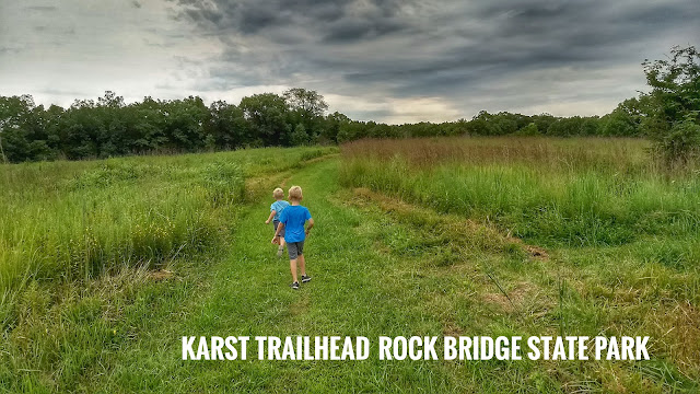
The trail started out like this - a wide mowed grassy area that overlooked grassland type fields. It was easy terrain throughout the trail although the elevation did change slightly at times.
The trail started out like this - a wide mowed grassy area that overlooked grassland type fields. It was easy terrain throughout the trail although the elevation did change slightly at times.

The name Karst Trail actually derives from the term karst topography. I had to look it up to find out that karst topography (in the case of this trail) is indicative of sinkholes in the area. That's good for wildlife because sinkholes can hold water.
I love this picture of my three boys and the incoming clouds from the west!
I love this picture of my three boys and the incoming clouds from the west!

Included along the grassland section of the trail is also a 3 acre prairie.

We saw several patches of these late summer wild flowers.

Another view of the landscape.

And another. I don't know if it was the incoming rain or just our luck for the day, but we saw tons of bunnies on this hike. They weren't interested in posing for pictures though.

There were several spots where you could opt to veer off the main path to another loop, but we stayed on the main one.
The grassy trail was perfect for footraces!
The grassy trail was perfect for footraces!

And then we came across this tree that formed an arch over the trail that I immediately thought would be a beautiful place for a wedding. Except, I don't know anyone getting married anytime soon...

The grassy path kept winding around for probably about a mile or a little more. But it was beautiful the entire way. This is a perfect cloudy day hiking trail since there's not much shade on this part.

A little watering hole for animals.

And another race for the front of the pack. I probably have a couple hundred pictures of these 2 doing this exact thing on various trails we have hiked over the years.

And another field of flowers.

And finally the trail led us into the woods that had been on the periphery of our view during the grassland portion of the hike.

And again, the trail was beautifully maintained and easy to traverse. And the woods around it weren't that dense so the views were still really pretty.

From here, the path led in and out of the woods for another mile (or just under).

In the woods...

Out of the woods...

Grassy path...

Dirt path...

Until we came to the grassy clearing where we started. The picture below is actually looking back into the woods from where we had just come. You can also enter this way at the beginning if you take the loop in reverse.

And with an easy hike behind us, we headed back to the car.

Some hiking info:
We hiked on a Saturday morning and ran into 3-4 other hikers. The trail sign says that dogs should be on leashes, but we did come across some that weren't. Just something to keep in mind if you're hiking with dogs.You can get more info on this trail here:
Missouri State Parks - Trails
or here:
Alltrails.com
You can also see some of our other hikes as well as info on Missouri Department of Conservation on my blog here.
Stats from the hike via Geo Tracker


And that's a wrap. Happy Hiking.


Comments
Post a Comment